
The U.S. Air Force 53rd Weather Reconnaissance Squadron, commonly known as the Hurricane Hunters, is slated to perform “Atmospheric Rivers recon” from January through March, according to a recent service news release.
Scientists led by Scripps Institution of Oceanography at University of California, San Diego, in partnership with the 53rd WRS, National Oceanic and Atmospheric Aviation’s National Weather Service and Office of Marine and Aviation Operations, will be on standby to fly through these ARs over the Pacific to gather data to improve forecasts.
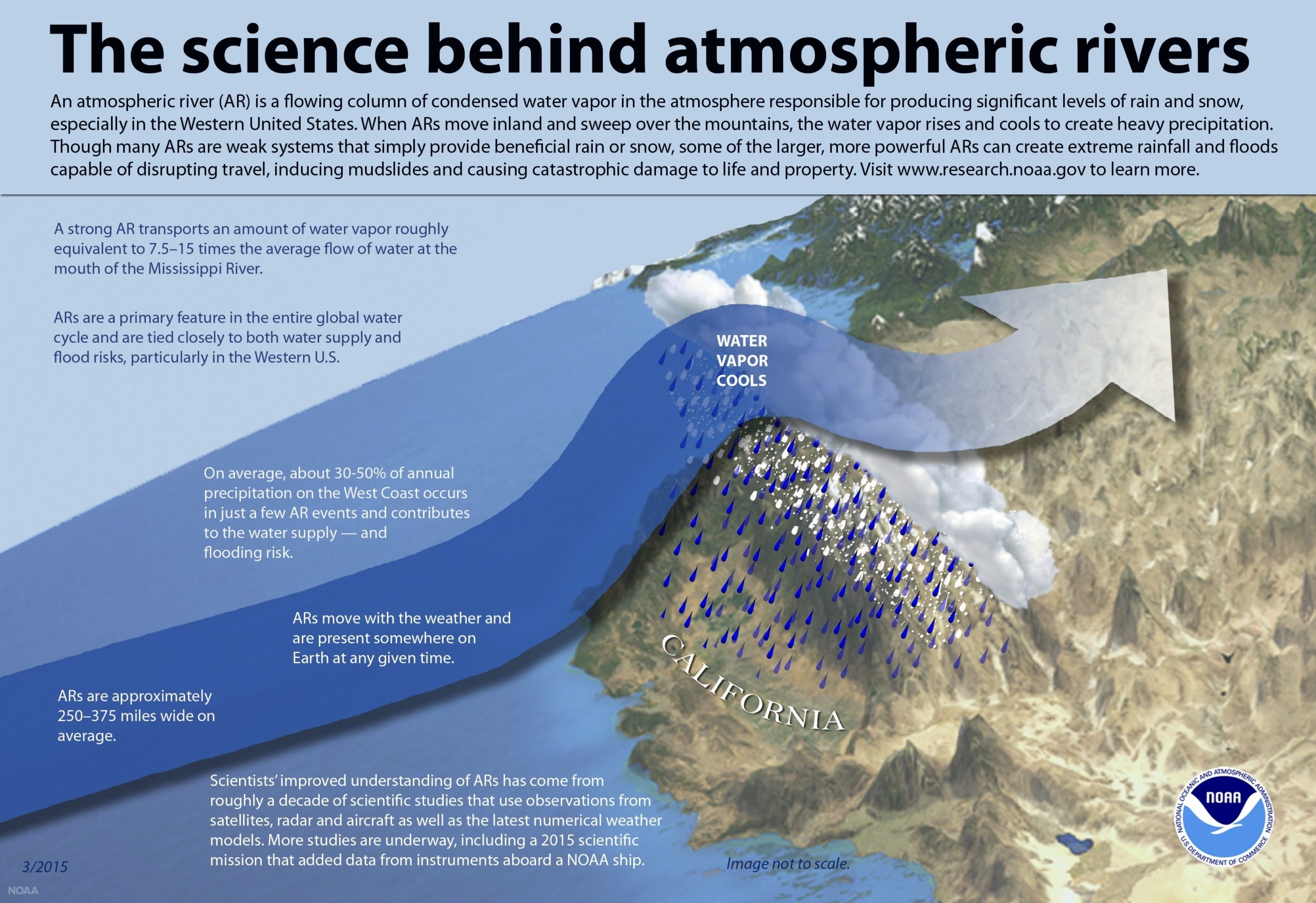
“There is no off season for us, after the Hurricane season is done we roll into the Winter Storm season and part of that is providing support for atmospheric rivers off the West Coast,” said Lt. Col. Ryan Rickert, 53rd WRS aerial reconnaissance weather officer. “ARs are flowing columns of water vapor that produce vast amounts of precipitation when they make landfall. The heavy amounts of precipitation can turn into extreme rainfall and snow, which then can cause flooding and mudslides.”
The Hurricane Hunters are slated to perform “AR recon” from January through March. Scientists led by Scripps Institution of Oceanography at University of California, San Diego, working in partnership with the 53rd WRS, National Oceanic and Atmospheric Administration’s National Weather Service, and Office of Marine and Aviation Operations, who will be on standby to fly through these ARs over the Pacific to gather data to improve forecasts. Approximately twelve storms will be flown during that period and deploying up to three planes per storm.
“We’re trying to improve the forecast of atmospheric rivers on the West Coast, because it matters to the people who manage water and deal with the hazards of flood and debris flows,” said F. Martin Ralph, principal investigator for the AR Recon program and director of the Center for Western Weather and Water Extremes at Scripps. “We’re all working together to try and figure out how to make the forecast better and AR recon’s data gathering is a vital part of that.”
There are two WC-130J Super Hercules aircraft from the 403rd Wing which have staged at Travis Air Force Base, Calif., then moved to Portland, Ore., and U.S. Coast Guard Air Station Barbers Point in Hawaii. One Gulfstream IV from NOAA’s Air Operations Center is also staged out of Portland.
“In many cases ARs are great for the state of California, because they bring 90 percent of the state’s annual precipitation,” said Ralph. “But when the ground is already saturated and more water is added, it can cause hazards, so knowing what is coming helps people to prepare.”
ARs have a great economic impact on California and its residents, said Ralph. They are the dominant cause of flooding and play key roles in drought in West Coast watersheds. Flood costs average about $1 billion dollars a year and produce 25-50 percent of the water supply in key areas of the West.
During AR missions, the 53rd WRS fly up to 30,000 feet to capture as much atmospheric data as possible. The data compiled by dropsondes can create a vertical profile from the aircraft to the surface of the ocean for the research team and forecasters to input in their models.
“We have somewhat of a void in collecting data over the ocean. Satellites have trouble seeing through clouds, thus having an aircraft releasing dropsondes in those areas significantly improves our data and the forecast models.” said Anna Wilson, field research manager of the Center for Western Weather and Water Extremes. “We have a lot of room for accuracy and prediction improvements, and aerial weather reconnaissance is vital to gathering data from within the atmospheric rivers with lead times of about 3 days to help improve our weather models.”
The data that is collected from the aircraft is uploaded to forecast models, but the three primary models utilized by the research teams are the Naval Global Environmental Model (NAVGEM), the European Center for Medium Range Weather Forecasts (ECMWF) and NOAA’s Global Forecasting System (GFS) which is produced by the National Centers for Environmental Prediction.
“The observations gathered by the WC-130J definitely help bridge the gaps in data,” said Wilson. “It would be great to have more aircraft, because we have found in our results that all the spatial coverage helps make the impact larger, which helps predict where an atmospheric river will make landfall.”
An AR can be hundreds of miles wide and have their own categories from 1 to 5, the higher the number the increased hazard. An AR can range from 250 – 500 miles wide on average, said Ralph.
“Having the Air Force here on site doing the flight planning with us is extremely helpful on both sides, it makes us more effective and efficient. It’s awesome being able to have them here in person,” said Wilson. “We have a robust team with national and international participation that use the gathered data and input for three of the global forecast models.”
While the aircraft and aircrews can be staged at different locations, there is an additional team working hand-in-hand with the research team at Scripps who are in charge of mission development and coordination with the flying aircrew.
“Being on site really helps prevent miscommunications between the research team and the assets the 53rd has to offer,” said Rickert. “As soon as the research team finds an area of interest for weather observations, we immediately start coordinating a flight plan that is feasible for our crews and make adjustments for times and fuel.”
Rickert said that gathering data from any weather flight ultimately helps the people on the ground who are going to be affected.
“Gathering data from within storm environments is inherently dangerous, but we perform this service all the same, whether it is flying into a CAT 5 hurricane or an AR 5, we collect data in hopes to improve the weather forecast and in turn save lives in the process,” said Rickert.